Detail View: NASA Earth Observatory Collection: Typhoon Songda
|
Title:
|
Typhoon Songda
|
|
Description:
|
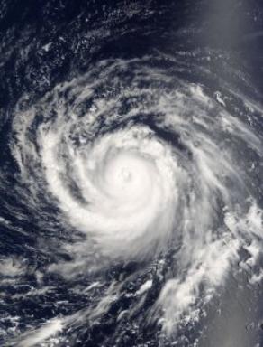
The MODIS instrument aboard NASA's Terra satellite captured this true-color image of Typhoon Songda on September 1, 2004 at 00:40 UTC. At the time this image was taken Songda was located approximately 740 km (460 miles) southeast of Iwo Jima, Japan and was moving towards the northwest at 28 km/hr (17 mph). Maximum sustained winds were near 232 km/hr (144 mph) with higher gusts to 278 km/hr (173 mph). The MODIS Rapid Response System provides this image at additional resolutions and formats. NASA image courtesy Jacques Descloitres, MODIS Land Rapid Response Team at NASA GSFC.
|
|
Satellite - Sensor:
|
Terra- MODIS
|
|
facet_what:
|
Terra
|
|
facet_where:
|
Goddard Space Flight Center (GSFC)
|
|
facet_when:
|
September 1, 2004
|
|
facet_when_year:
|
2004
|
|
UID:
|
SPD-ETOBS-12387
|
|
original url:
|
http://earthobservatory.nasa.gov/NaturalHazards/natural_hazards_v2.php3?img_id=12387
|