COLLECTION NAME:
NASA Jet Propulsion Laboratory Collection
Record
Title:
Pasadena, California
Creator:
NASA/JPL-Caltech
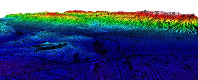
Description:
This three-dimensional image of western section of Pasadena, California was created with data from NASA's Airborne Synthetic Aperture Radar (AIRSAR). Topographic heights were generated using radar interferometry, a technique that combines two radar images to simulate this perspective view. The San Gabriel Mountains provide a backdrop for this perspective view of western part of Pasadena. The Arroyo Seco, home of the Brookside Golf Course and the Rose Bowl, is the dark patch in the center. Scholl Canyon Landfill in the Verdugo Hills is the dark patch left of the Arroyo. This type of high-resolution topographic information can provide important information to urban planners. Colors correspond to topographic heights above sea level with white being the highest and purple the lowest. This elevation information is draped over a radar image. Overall, the elevations in the image range from 300 to 2000 meters above sea level. These data were collected in early June 1996.
Date:
8/13/98
Identifier:
P-49878
MediaType:
Image
MediaType:
Image
Year:
1998
Contributor:
JPL Archives
What:
Airborne Synthetic Aperture Radar
Where:
California
Link To Source