COLLECTION NAME:
NASA Jet Propulsion Laboratory Collection
Record
Title:
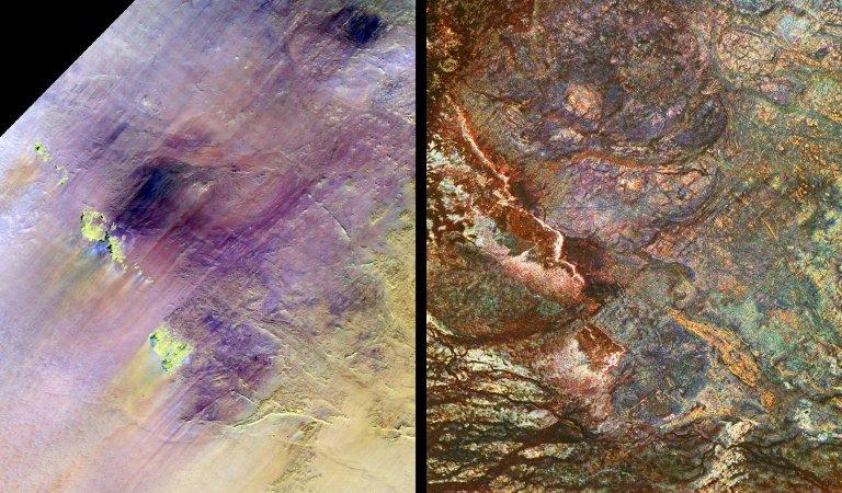
Safsaf Oasis, Egypt SIR-C/X-SAR - Landsat Comparison
Creator:
NASA/JPL-Caltech
Description:
These images show two views of a region of south-central Egypt, each taken by a different type of spaceborne sensor. On the left is an optical image from the Landsat Thematic Mapper , and on the right is a radar image from the Spaceborne Imaging Radar-C/X-band Synthetic Aperture Radar (SIR-C/X-SAR). This comparison shows that the visible and infrared wavelengths of Landsat are only sensitive to the materials on the surface, while the radar wavelengths of SIR-C/X-SAR can penetrate the thin sand cover in this arid region to reveal details hidden below the surface. Field studies in this area indicate that the L-band radar can penetrate as much as 2 meters (6.5 feet) of very dry sand to image buried rock structures. Ancient drainage channels, shown at the bottom of this image, are filled with sand more than 2 meters (6.5 feet) thick and therefore appear dark because the radar waves cannot penetrate them. Only the most recently active channels are visible in the Landsat scene. Some geologic structures at the surface are visible in both images. However, many buried features, such as rock fractures and the blue circular granite bodies in the upper center of the image on the right, are visible only to the radar. The Safsaf Oasis is located near the bright yellow feature in the lower left center of the Landsat image. Scientists are using the penetrating capabilities of radar imaging in desert areas to study structural geology, mineral exploration, ancient climates, water resources and archaeology. Each image is 30.8 kilometers by 25.6 kilometers (19.1 miles by 15.9 miles) and is centered at 22.7 degrees north latitude, 29.3 degrees east longitude. North is toward the upper right. In the Landsat image, the colors are assigned as follows: red is Band 7 (mid-infrared); green is Band 4 (near infrared); and blue is Band 1 (visible blue light). The colors assigned to the radar frequencies and polarizations are as follows: red is L- band, horizontally transmitted and received; green is C-band, horizontally transmitted and received; and blue is X-band, vertically transmitted and received. The radar image was acquired by the Spaceborne Imaging Radar-C/X-band Synthetic Aperture Radar (SIR-C/X-SAR) on April 16, 1994, on board the space shuttle Endeavour. SIR-C/X-SAR, a joint mission of the German, Italian and United States space agencies, is part of NASA's Earth Science Enterprise. The Landsat Program is managed jointly by NASA, the National Oceanic and Atmospheric Administration and the United States Geological Survey.
Date:
3/26/98
Identifier:
P-49668
MediaType:
Image
MediaType:
Image
Year:
1998
Contributor:
JPL Archives
What:
Spaceborne Imaging Radar-C/X-Band Synthetic Aperture Radar
What:
Landsat
What:
L-Band Radar
What:
Space Shuttle Endeavour
What:
Earth
Where:
United States of America
Link To Source